Aeolus ESA MAAP Data Access Example for Aeolus L1B#
@ ESA, 2025 = Licensed under “European Space Agency Community License”
Author: Saskia Brose (saskia.brose@esa.int)
Last Updated: 17-11-2025
NEW features:
Long lasting token
JSON keys for EarthCARE data files renamed
This script shows how to query the ESA MAAP catalog and stream/download AEOLUS data in combination with the Coda library and a reader provided by Stefanie Knobloch (04/09/2025).
Setup CODA Definition Path and Environment Variable#
import os

# Define the CODA definition folder version; Ensure the correct path separator is used
codadef_version = 'codadef-aeolus-20231201'

# Build the full path to the CODA definition directory: Join the current working directory and the definition folder
codadef_path = os.path.join(os.getcwd(), codadef_version)

# Check if the codadef directory exists
if not os.path.exists(codadef_path):
    raise FileNotFoundError(f'Archive {codadef_version} not found. Make sure '
                            f'that the archive exists in the current working directory ...')

# Set the CODA_DEFINITION environment variable
os.environ['CODA_DEFINITION'] = codadef_path

# Check if it's set correctly
print("CODA_DEFINITION:", os.getenv('CODA_DEFINITION'))
CODA_DEFINITION: c:\Users\saskia.brose\Documents\Repos\Dataaccess\codadef-aeolus-20231201
Prerequisites#
Make sure these come after you set the codadef path as an environment variable!
import xarray as xr
import numpy as np
from numpy import hstack, vstack
import re
import requests
from datetime import datetime
import xml.etree.ElementTree as ET
import fsspec
import tempfile
import pathlib
import coda
import matplotlib.pyplot as plt
from pystac_client import Client
from tqdm import tqdm
import pandas as pd
from IPython.display import Image, display
L1b Reader#
A2S products reader.
@author: Stefanie Knobloch
Last update: 04.09.2025
class L1b_reader:

    def __init__(self, cf):
        self.cf = cf
        self.file = xr.Dataset({})

    L1B_LOCATIONS = {
        # Geolocation ---------------------------------------------------------
        'start_of_observation_time':                ['geolocation', -1, 'start_of_observation_time'],
        'time':                                     ['geolocation', -1, 'observation_aocs', 'observation_centroid_time'],
        'roll_angle':                               ['geolocation', -1, 'observation_aocs', 'roll_angle'],
        'meas_time':                                ['geolocation', -1, 'measurement_aocs',-1, 'measurement_centroid_time'],
        'longitude_of_DEM_intersection':            ['geolocation', -1, 'observation_geolocation', 'geolocation_of_dem_intersection', 'longitude_of_dem_intersection'],
        'latitude_of_DEM_intersection':             ['geolocation', -1, 'observation_geolocation', 'geolocation_of_dem_intersection', 'latitude_of_dem_intersection'],
        'altitude_of_DEM_intersection':             ['geolocation', -1, 'observation_geolocation', 'geolocation_of_dem_intersection', 'altitude_of_dem_intersection'],
        'argument_of_latitude_of_DEM_intersection': ['geolocation', -1, 'observation_geolocation', 'geolocation_of_dem_intersection', 'argument_of_latitude_of_dem_intersection'],
        'sun_elevation_at_DEM_intersection':        ['geolocation', -1, 'observation_geolocation', 'geolocation_of_dem_intersection', 'sun_elevation_at_dem_intersection'],
        'mie_longitude':                            ['geolocation', -1, 'observation_geolocation', 'observation_mie_geolocation', -1, 'longitude_of_height_bin'],
        'mie_latitude':                             ['geolocation', -1, 'observation_geolocation', 'observation_mie_geolocation', -1, 'latitude_of_height_bin'],
        'ray_longitude':                            ['geolocation', -1, 'observation_geolocation', 'observation_rayleigh_geolocation', -1, 'longitude_of_height_bin'],
        'ray_latitude':                             ['geolocation', -1, 'observation_geolocation', 'observation_rayleigh_geolocation', -1, 'latitude_of_height_bin'],
        'mie_altitude':                             ['geolocation', -1, 'observation_geolocation', 'observation_mie_geolocation', -1, 'altitude_of_height_bin'],
        'ray_altitude':                             ['geolocation', -1, 'observation_geolocation', 'observation_rayleigh_geolocation', -1, 'altitude_of_height_bin'],
        'mie_altitude_meas':                        ['geolocation', -1, 'measurement_geolocation', -1, 'mie_geolocation',-1, 'altitude_of_height_bin'],
        'rayleigh_altitude_meas':                   ['geolocation', -1, 'measurement_geolocation', -1, 'rayleigh_geolocation',-1, 'altitude_of_height_bin'],
        'mie_range':                                ['geolocation', -1, 'observation_geolocation', 'observation_mie_geolocation', -1, 'satellite_range_of_height_bin'],
        'ray_range':                                ['geolocation', -1, 'observation_geolocation', 'observation_rayleigh_geolocation', -1, 'satellite_range_of_height_bin'],
        'sun_elevation_at_DEM_intersection_meas':   ['geolocation', -1, 'measurement_geolocation', -1, 'geolocation_of_dem_intersection', 'sun_elevation_at_dem_intersection'],
        'topocentric_elevation_of_height_bin':      ['geolocation', -1, 'observation_geolocation', 'observation_rayleigh_geolocation', -1, 'topocentric_elevation_of_height_bin'],

        # Instrument ----------------------------------------------------------
        'mie_measurement_data':                     ['measurement', -1, 'mie_measurement_data'],
        # 'ray_measurement_data':                     ['measurement', -1, 'rayleigh_measurement_data'],
        'mie_useful_signal':                        ['useful_signal', -1, 'observation_useful_signals', 'mie_altitude_bin_useful_signal_info', -1, 'useful_signal'],
        'mie_useful_signal_data_quality_flag':      ['useful_signal', -1, 'observation_useful_signals', 'mie_altitude_bin_useful_signal_info', -1, 'data_quality_flag'],
        'ray_useful_signal_a':                      ['useful_signal', -1, 'observation_useful_signals', 'rayleigh_altitude_bin_useful_signal_info', -1, 'useful_signal_channel_a'],
        'ray_useful_signal_b':                      ['useful_signal', -1, 'observation_useful_signals', 'rayleigh_altitude_bin_useful_signal_info', -1, 'useful_signal_channel_b'],
        'ray_useful_signal_data_quality_flag':      ['useful_signal', -1, 'observation_useful_signals', 'rayleigh_altitude_bin_useful_signal_info', -1, 'data_quality_flag'],
        'mie_us_meas' :                             ['useful_signal', -1, 'measurement_useful_signal', -1, 'mie_altitude_bin_useful_signal_info', -1, 'useful_signal'],
        'ray_us_a_meas':                            ['useful_signal', -1, 'measurement_useful_signal', -1, 'rayleigh_altitude_bin_useful_signal_info', -1, 'useful_signal_channel_a'],
        'ray_us_b_meas':                            ['useful_signal', -1, 'measurement_useful_signal', -1, 'rayleigh_altitude_bin_useful_signal_info', -1, 'useful_signal_channel_b'],
        'n':                                        ['product_confidence_data', -1, 'n'],
        'p':                                        ['product_confidence_data', -1, 'p'],
        'mie_integration_time':                     ['measurement', -1, 'mie_time_delays', 'bin_layer_integration_time'],
        'ray_integration_time':                     ['measurement', -1, 'rayleigh_time_delays', 'bin_layer_integration_time'],
        'mie_bkg_integration_time':                 ['measurement', -1, 'mie_time_delays', 'background_integration_time'],
        'ray_bkg_integration_time':                 ['measurement', -1, 'rayleigh_time_delays', 'background_integration_time'],
        'ray_mean_emitt_freq':                      ['product_confidence_data', -1, 'observation_pcd', 'rayleigh_mean_emitted_frequency'],
        'ray_std_emitt_freq':                       ['product_confidence_data', -1, 'observation_pcd', 'rayleigh_emitted_frequency_std_dev'],
        'mie_mean_emitt_freq':                      ['product_confidence_data', -1, 'observation_pcd', 'mie_mean_emitted_frequency'],
        'mie_std_emitt_freq':                       ['product_confidence_data', -1, 'observation_pcd', 'mie_emitted_frequency_std_dev'],

        # Preliminary wind ----------------------------------------------------
        'mie_wind':                                 ['wind_velocity', -1, 'observation_wind_profile', 'mie_altitude_bin_wind_info',-1, 'wind_velocity'],
        'mie_wind_flag':                            ['wind_velocity', -1, 'observation_wind_profile', 'mie_altitude_bin_wind_info',-1, 'bin_quality_flag'],
        'ray_wind':                                 ['wind_velocity', -1, 'observation_wind_profile', 'rayleigh_altitude_bin_wind_info',-1, 'wind_velocity'],
        'ray_wind_flag':                            ['wind_velocity', -1, 'observation_wind_profile', 'rayleigh_altitude_bin_wind_info',-1, 'bin_quality_flag'],
        'mie_wind_meas':                            ['wind_velocity', -1, 'measurement_wind_profile', -1, 'mie_altitude_bin_wind_info',-1, 'wind_velocity'],
        'mie_wind_meas_flag':                       ['wind_velocity', -1, 'measurement_wind_profile', -1, 'mie_altitude_bin_wind_info',-1, 'bin_quality_flag'],
        'ray_wind_meas':                            ['wind_velocity', -1, 'measurement_wind_profile', -1, 'rayleigh_altitude_bin_wind_info',-1, 'wind_velocity'],
        'ray_wind_meas_flag':                       ['wind_velocity', -1, 'measurement_wind_profile', -1, 'rayleigh_altitude_bin_wind_info',-1, 'bin_quality_flag'],
        'LOS_flag':                                 ['wind_velocity', -1, 'line_of_sight_wind_flag'],
        # SNR -----------------------------------------------------------------
        'ray_meas_signal_to_noise_ratio_channel_a': ['product_confidence_data', -1, 'measurement_pcd', -1,'meas_alt_bin_pcd', -1, 'rayleigh_signal_to_noise_ratio_channel_a'],
        'ray_meas_signal_to_noise_ratio_channel_b': ['product_confidence_data', -1, 'measurement_pcd', -1,'meas_alt_bin_pcd', -1, 'rayleigh_signal_to_noise_ratio_channel_b'],
        'mie_meas_signal_to_noise_ratio':           ['product_confidence_data', -1, 'measurement_pcd', -1,'meas_alt_bin_pcd', -1, 'mie_signal_to_noise_ratio'],
        'ray_obs_signal_to_noise_ratio_channel_a':  ['product_confidence_data', -1, 'observation_pcd', 'observation_alt_bin_pcd', -1, 'rayleigh_signal_to_noise_ratio_channel_a'],
        'ray_obs_signal_to_noise_ratio_channel_b':  ['product_confidence_data', -1, 'observation_pcd', 'observation_alt_bin_pcd', -1, 'rayleigh_signal_to_noise_ratio_channel_b'],
        'mie_obs_signal_to_noise_ratio':            ['product_confidence_data', -1, 'observation_pcd', 'observation_alt_bin_pcd', -1, 'mie_signal_to_noise_ratio'],

        'mie_refined_scattering_ratio':             ['product_confidence_data', -1, 'observation_pcd', 'observation_alt_bin_pcd', -1, 'refined_scattering_ratio_mie'],
        'mie_refined_signal_to_noise_ratio':        ['product_confidence_data', -1, 'observation_pcd', 'observation_alt_bin_pcd', -1, 'refined_mie_signal_to_noise_ratio'],
        'mie_scattering_ratio':                     ['product_confidence_data', -1, 'observation_pcd', 'observation_alt_bin_pcd', -1, 'scattering_ratio_mie'],
        #'mie_refined_SR_SNR_flag':                  ['product_confidence_data', -1, 'observation_pcd', 'observation_alt_bin_pcd', -1, 'Refined_SR_SNR_Data_Quality_Flag'],
        'mie_refined_scattering_ratio_measurement': ['product_confidence_data', -1, 'measurement_pcd', -1, 'meas_alt_bin_pcd', -1, 'refined_scattering_ratio_mie'],
        #'mie_refined_SR_SNR_meas_flag':             ['product_confidence_data', -1, 'measurement_pcd', -1, 'meas_alt_bin_pcd', -1, 'Refined_SR_SNR_Data_Quality_Flag'],
        'mie_core_resiudal_error':                  ['product_confidence_data', -1, 'observation_pcd', 'observation_alt_bin_pcd', -1, 'mie_core_characteristic','residual_error'],
        'mie_core_residual_error_meas':             ['product_confidence_data', -1, 'measurement_pcd', -1, 'meas_alt_bin_pcd', -1, 'mie_core_characteristic','residual_error'],
        'mie_core_resiudal_error_flag':             ['product_confidence_data', -1, 'observation_pcd', 'observation_alt_bin_pcd', -1, 'mie_core_characteristic','error_flag'],
        'mie_refined_SNR_ratio_meas':               ['product_confidence_data', -1, 'measurement_pcd', -1, 'meas_alt_bin_pcd', -1, 'refined_mie_signal_to_noise_ratio'],
        'ray_ground_corr_velocity':                 ['ground_wind_detection', -1, 'rayleigh_ground_correction_velocity'],
        'mie_ground_corr_velocity':                 ['ground_wind_detection', -1, 'mie_ground_correction_velocity'],
        'updated_mie_ground_correction_velocity':   ['ground_wind_detection', -1, 'updated_mie_ground_correction_velocity'],
        'updated_ray_ground_correction_velocity':   ['ground_wind_detection', -1, 'updated_rayleigh_ground_correction_velocity'],
        'mie_ground_useful_signal':                 ['ground_wind_detection', -1, 'mie_ground_useful_signal'],
        'rayleigh_ground_useful_signal':            ['ground_wind_detection', -1, 'rayleigh_ground_useful_signal'],

    }


    def ray_mie_signals_observation(self):

        self.file['start_of_observation_time'] = (['obs'], coda.fetch(self.cf, *self.L1B_LOCATIONS['start_of_observation_time']))
        self.file['time'] = (['obs'], coda.fetch(self.cf, *self.L1B_LOCATIONS['time']))
        self.file['time_str'] = coda.time_to_string(self.file['time'].values) # [datetime.utcfromtimestamp(int(t) + datetime(2000, 1, 1, 0, 0, 0).timestamp()).strftime('%Y%m%d %H:%M:%S') for t in self.file['time']]
        self.file['mie_longitude'] = (['obs', 'layer25'], np.vstack(coda.fetch(self.cf, *self.L1B_LOCATIONS['mie_longitude'])))
        self.file['ray_longitude'] = (['obs', 'layer25'], np.vstack(coda.fetch(self.cf, *self.L1B_LOCATIONS['ray_longitude'])))
        self.file['longitude_of_DEM_intersection'] = (['obs'], coda.fetch(self.cf, *self.L1B_LOCATIONS['longitude_of_DEM_intersection']))
        self.file['latitude_of_DEM_intersection'] = (['obs'], coda.fetch(self.cf, *self.L1B_LOCATIONS['latitude_of_DEM_intersection']))
        self.file['argument_of_latitude'] = (['obs'], coda.fetch(self.cf, *self.L1B_LOCATIONS['argument_of_latitude_of_DEM_intersection']))
        self.file['altitude_of_DEM_intersection'] = (['obs'], coda.fetch(self.cf, *self.L1B_LOCATIONS['altitude_of_DEM_intersection']))
        self.file['mie_altitude'] = (['obs', 'layer25'], np.vstack(coda.fetch(self.cf, *self.L1B_LOCATIONS['mie_altitude'])))
        self.file['ray_altitude'] = (['obs', 'layer25'], np.vstack(coda.fetch(self.cf, *self.L1B_LOCATIONS['ray_altitude'])))
        self.file['mie_range'] = (['obs', 'layer25'], np.vstack(coda.fetch(self.cf, *self.L1B_LOCATIONS['mie_range'])))
        self.file['ray_range'] = (['obs', 'layer25'], np.vstack(coda.fetch(self.cf, *self.L1B_LOCATIONS['ray_range'])))
        self.file['ray_useful_signal_a'] = (['obs', 'layer25'], np.vstack(coda.fetch(self.cf, *self.L1B_LOCATIONS['ray_useful_signal_a'])))
        self.file['ray_useful_signal_b'] = (['obs', 'layer25'], np.vstack(coda.fetch(self.cf, *self.L1B_LOCATIONS['ray_useful_signal_b'])))
        self.file['ray_useful_signal_data_quality_flag'] = (['obs', 'layer25'], np.vstack(coda.fetch(self.cf, *self.L1B_LOCATIONS['ray_useful_signal_data_quality_flag'])))
        self.file['mie_useful_signal'] = (['obs', 'layer25'], np.vstack(coda.fetch(self.cf, *self.L1B_LOCATIONS['mie_useful_signal'])))
        self.file['mie_useful_signal_data_quality_flag'] = (['obs', 'layer25'], np.vstack(coda.fetch(self.cf, *self.L1B_LOCATIONS['mie_useful_signal_data_quality_flag'])))
        # ... add or delete parameters
        return self.file
Using the STAC API to query the ESA MAAP stac catalog#
The discovery of data (querying the ESA MAAP catalogue) does not require any authentication or authorization and is open to anyone. Accessing data requires a token generated with an authorized eoiam account (EO Sign in) to verify the user. This will be demonstrated later on.
# Point to the STAC API of the ESA MAAP catalogue
catalog_url = 'https://catalog.maap.eo.esa.int/catalogue/'
catalog = Client.open(catalog_url)
The first step of finding data is to select the collection. For AEOLUS, for example, collections include AeolusL0ProductsB16, AeolusL1AProducts, AeolusL2AProducts, or AeolusAdditionalProducts. For a full set of collections from the Aeolus mission we can filter collections by platform.
# Search for Aeolus collections in the catalogue
results = catalog.collection_search(
    filter="platform='" + 'Aeolus' + "'"
)
print(f"{results.matched()} collections found.")

data = results.collection_list_as_dict()
df = pd.json_normalize(data, record_path=['collections'])

df[['id', 'title']]
13 collections found.
| id | title | |
|---|---|---|
| 0 | AeolusL2BProducts | Aeolus L2B Products |
| 1 | AeolusL2AProducts | Aeolus L2A Products |
| 2 | AeolusL0ProductsB16 | Aeolus L0 Products |
| 3 | AeolusAdditionalProducts | Aeolus Additional Products |
| 4 | AeolusEOLL2CProducts | Aeolus EOL L2C Products |
| 5 | AeolusL2BBUFRProducts | Aeolus L2B BUFR Products |
| 6 | AeolusEOLL2AProducts | Aeolus EOL L2A Products |
| 7 | AeolusEOLL1BProducts | Aeolus EOL L1B Products |
| 8 | AeolusL1BProducts | Aeolus L1B Products |
| 9 | AeolusL1AProducts | Aeolus L1A Products |
| 10 | AeolusEOLL2BProducts | Aeolus EOL L2B Products |
| 11 | AeolusL1ANetCDFProducts | Aeolus L1A NetCDF Products |
| 12 | AeolusEOLL1AProducts | Aeolus EOL L1A Products |
# Select one (or several) collections. Note that if you select more than one collection, the query will only work if you use filters that exist across both collections.
AE_COLLECTION = ['AeolusL1BProducts']
#AE_COLLECTION = ['AeolusL1BProducts','AeolusL2BProducts']
The second step is to further narrow down your search:
Datetime represents the temporal coverage of the data. None can be used for both start and end to indicated unbounded queries.
bbox is defined by the bottom left corner (longmin latmin) and the top right corner coordinates (longmax latmax).
Filter – allows you to search based on different metadata parameters.
To understand which queryables exist, you can visit:
https://catalog.maap.eo.esa.int/catalogue/collections/<insertcollectionname>/queryables
This URL shows the available queryable fields for a given collection.
On top of the spatial (bbox) and temporal (datetime) filters, you can build queries with filters such as these:
Acquisition type,
Processing Date, Creation Date, Modification Date
Instrument,
Platform,
Orbit number,
Processing center,
Item ID,
Product version,
Processing level,
Sensor type,
Product status,
Processor name,
Sensor mode,
Product type
search = catalog.search(
    collections=AE_COLLECTION,
    filter="processingCenter = 'APF' and orbitNumber = 27018", # filters can be combined using AND/OR operators
    datetime = ['2023-01-29T00:00:00Z', None],
    bbox = [0, -20, 10, -10],
    method = 'GET', # This is necessary
    max_items=5  # Not necessary, adjust as needed
)

items = list(search.items())
print(f"Accessing {len(items)} items (limited by max_items).")
print(f"{search.matched()} items found that matched the query.")
Accessing 1 items (limited by max_items).
1 items found that matched the query.
items
[<Item id=AE_OPER_ALD_U_N_1B_20230422T165721033_005543989_027018_0001>]
Results#
What Are Assets?#
In a STAC catalog, assets are the individual files linked to a catalog item — such as imagery, metadata, thumbnails, or masks.
Exploring assets helps you understand what data products are available for download or analysis.
🔍 This step is optional but useful for discovering the structure and content of your selected product.
⚠️ For Aeolus the files previously stored in enclosure_X are now stored under enclosure_dbl, enclosure_hdr, enclosure_eef
# Access the first item only
item = items[0]

print(f"Item 0 — ID: {item.id if hasattr(item, 'id') else item.get('id')}")

# If item is a pystac.Item
try:
    assets = item.assets
except AttributeError:
    # If item is a dict
    assets = item.get("assets", {})

if assets:
    print("  Available asset keys:")
    for key in assets.keys():
        print("   -", key)
else:
    print("  No assets found for this item.")
Item 0 — ID: AE_OPER_ALD_U_N_1B_20230422T165721033_005543989_027018_0001
  Available asset keys:
   - thumbnail
   - product
   - enclosure_dbl
   - metadata_ogc_10_157r4
   - metadata_ogc_17_003r2
   - metadata_iso_19139
   - enclosure_hdr
   - enclosure_eef
# Create a list of asset keys and their URLs
asset_data = []
if assets:
    for key, asset in assets.items():
        href = asset.href if hasattr(asset, 'href') else asset.get('href')
        asset_data.append({'Asset Key': key, 'URL': href})
else:
    print("No assets found for this item.")

# Create a DataFrame for visualization and access
df_assets = pd.DataFrame(asset_data)
df_assets
| Asset Key | URL | |
|---|---|---|
| 0 | thumbnail | https://catalog.maap.eo.esa.int/data/aeolus-01... |
| 1 | product | https://catalog.maap.eo.esa.int/data/zipper/ae... |
| 2 | enclosure_dbl | https://catalog.maap.eo.esa.int/data/aeolus-01... |
| 3 | metadata_ogc_10_157r4 | https://catalog.maap.eo.esa.int/catalogue/coll... |
| 4 | metadata_ogc_17_003r2 | https://catalog.maap.eo.esa.int/catalogue/coll... |
| 5 | metadata_iso_19139 | https://catalog.maap.eo.esa.int/catalogue/coll... |
| 6 | enclosure_hdr | https://catalog.maap.eo.esa.int/data/aeolus-01... |
| 7 | enclosure_eef | https://catalog.maap.eo.esa.int/data/aeolus-01... |
Tips:
Want a quick look? Use the asset thumbnail to preview the data.
Want the full product? the asset key product points to the full zipped product.
Need to analyze? —
enclosure_dblcontains the binary data file, point toenclosure_hdr, if you want to access the header file.Don’t need everything? Avoid the .zip unless you really need to download all files.
Quicklook of the data#
You don’t need to authenticate or authorize to preview the data.
By referencing the thumbnail asset, you’re accessing a remote URL where a quicklook image of the product is stored.
This provides a fast and convenient way to visually inspect the data before downloading or processing it.
ql_url = df_assets[df_assets["Asset Key"] == "thumbnail"]["URL"].values[0]
display(Image(url=ql_url))

Token#
You can generate an offline access token that is valid for 90 days here. We recommend to save this personal offline token in a separate file and not paste it into your scripts. This offline access token in combination with a client ID and secret creates a refresh token which authenticates/authorizes you to access the data files. In simple terms, the offline token is like a temporary key that helps you securely log in without needing to re-enter your credentials every time.
# offline token link: https://portal.maap.eo.esa.int/ini/services/auth/token/90dToken.php
CLIENT_ID="offline-token"
CLIENT_SECRET="p1eL7uonXs6MDxtGbgKdPVRAmnGxHpVE"
# Save your personal offline token in a text file token_yourname.txt in the same directory as this script
if pathlib.Path("token_yourname.txt").exists():
  with open("token_yourname.txt","rt") as f:
    OFFLINE_TOKEN = f.read().strip().replace("\n","")
    url = "https://iam.maap.eo.esa.int/realms/esa-maap/protocol/openid-connect/token"
    data = {
        "client_id": CLIENT_ID,
        "client_secret": CLIENT_SECRET,
        "grant_type": "refresh_token",
        "refresh_token": OFFLINE_TOKEN,
        "scope": "offline_access openid"
    }

    response = requests.post(url, data=data)
    response.raise_for_status()

    response_json = response.json()
    access_token = response_json.get('access_token')
    print("Access token retrieved successfully.")

    if not access_token:
        raise RuntimeError("Failed to retrieve access token from IAM response")
Access token retrieved successfully.
Fetching the data#
# To plot the L1B data, we only need the dbl file:
l1b_url = df_assets[df_assets["Asset Key"] == "enclosure_dbl"]["URL"].values[0]
print(l1b_url)
https://catalog.maap.eo.esa.int/data/aeolus-01/AEOLUS/ALD_U_N_1B/1B16/2023/04/22/AE_OPER_ALD_U_N_1B_20230422T165721033_005543989_027018_0001/AE_OPER_ALD_U_N_1B_20230422T165721033_005543989_027018_0001/AE_OPER_ALD_U_N_1B_20230422T165721033_005543989_027018_0001.DBL
fs = fsspec.filesystem("https", headers={"Authorization": f"Bearer " + access_token})

# Create a temporary file for CODA
# Instead of reading the whole file at once (f.read(), we read chunks repeatedly in a loop)
with tempfile.NamedTemporaryFile(delete=False, suffix=".DBL") as tmp_file:
    with fs.open(l1b_url, "rb") as f:
        while True:
            chunk = f.read(8 * 2**20)  # Using 8 MB Chunks
            if not chunk:
                break
            tmp_file.write(chunk)
    tmp_path = tmp_file.name

try:
    product = coda.open(tmp_path)
    dataReader = L1b_reader(product)
    ds = dataReader.ray_mie_signals_observation()

finally:
    # Cleanup the temporary file
    coda.close(product)
    os.remove(tmp_path)
ds
<xarray.Dataset> Size: 927kB
Dimensions:                              (obs: 463, time_str: 463, layer25: 25)
Coordinates:
  * time_str                             (time_str) <U26 48kB '2023-04-22 16:...
Dimensions without coordinates: obs, layer25
Data variables: (12/17)
    start_of_observation_time            (obs) float64 4kB 7.355e+08 ... 7.35...
    time                                 (obs) float64 4kB 7.355e+08 ... 7.35...
    mie_longitude                        (obs, layer25) float64 93kB 4.04 ......
    ray_longitude                        (obs, layer25) float64 93kB 4.036 .....
    longitude_of_DEM_intersection        (obs) float64 4kB 4.424 3.99 ... 337.6
    latitude_of_DEM_intersection         (obs) float64 4kB 65.08 65.85 ... 71.09
    ...                                   ...
    ray_range                            (obs, layer25) float64 93kB 3.65e+05...
    ray_useful_signal_a                  (obs, layer25) float64 93kB 2.588e+0...
    ray_useful_signal_b                  (obs, layer25) float64 93kB 1.9e+03 ...
    ray_useful_signal_data_quality_flag  (obs, layer25) uint8 12kB 0 0 ... 192 0
    mie_useful_signal                    (obs, layer25) float64 93kB 1.356e+0...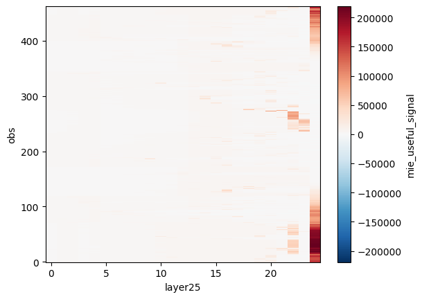
mie_useful_signal_data_quality_flag (obs, layer25) uint8 12kB 192 192 ... 0# Do something with the dataset
ds["mie_useful_signal"].plot()
<matplotlib.collections.QuadMesh at 0x23cf3624830>
Downloading data#
You can also use your token and the url to download data and not just stream it / load it into memory.
import requests
def download_file_with_bearer_token(url, token, disable_bar=False):
  """
  Downloads a file from a given URL using a Bearer token.
  """

  try:
    headers = {"Authorization": f"Bearer {token}"}
    response = requests.get(url, headers=headers, stream=True)
    response.raise_for_status()  # Raise an exception for bad status codes
    file_size = int(response.headers.get('content-length', 0))

    chunk_size = 8 * 1024 * 1024 # Byes - 1MiB
    file_path = url.rsplit('/', 1)[-1]
    print(file_path)
    with open(file_path, "wb") as f, tqdm(
        desc=file_path,
        total=file_size,
        unit='iB',
        unit_scale=True,
        unit_divisor=1024,
        disable=disable_bar,
      ) as bar:
      for chunk in response.iter_content(chunk_size=chunk_size):
        read_size=f.write(chunk)
        bar.update(read_size)

    if (disable_bar):
      print(f"File downloaded successfully to {file_path}")

  except requests.exceptions.RequestException as e:
    print(f"Error downloading file: {e}")
# Point to any URL of your choice in the STAC assets
download_file_with_bearer_token(l1b_url, token=access_token)
AE_OPER_ALD_U_N_1B_20230422T165721033_005543989_027018_0001.DBL
AE_OPER_ALD_U_N_1B_20230422T165721033_005543989_027018_0001.DBL: 100%|██████████| 27.3M/27.3M [00:09<00:00, 3.14MiB/s]